
Fietskaart - Wegenkaart Lake District and Cumbria nr. 3 | Ordnance Survey | 1:100.000 | ISBN 9780319263853
OS Tourmaps zijn overzichtelijke, gedetailleerde kaarten met veel toeristische informatie, waaronder campingaanduiding. Groot voordeel, naast de prima schaal, is dat de routes van het National Cycle Network duidelijk staan ingetekend.
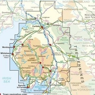
- ake District and Cumbria at 1:110,000 on the Ordnance Survey Tour Map No. 3. Insets show town navigation maps of Carlisle, Cockermouth, Workington, Whitehaven, Penrith, Keswick, Ambleside, Kendal, Windermere & Bowness, and Barrow-in-Furness, plus an overview of the whole area with cycle routes and national hiking trails. Additional topographic information along the coast shows sand, dunes, foreshore and high water mark. Also included is a list of selected places of interest.
About this series:
Ordnance Survey’s Tour series covers popular tourist areas of Great Britain on indexed regional road maps at varying scales, with extra clear, uncluttered cartography, national and regional cycle routes, national long-distance hiking trails, extensive tourist information and town navigation maps.
Topography is shown by altitude colouring, with additional relief shading, names of local hill or mountain ranges and heights of important peaks. Woodlands are coloured and national parks or designated Areas of Outstanding Natural Beauty are marked.
Road information very clearly distinguishes between different types of roads, from motorways to small local roads, with distances in miles on main routes. Motorway services, tolls, gradients on steep roads and level crossings are marked and towns used in motorway signs as Primary Route Destinations are highlighted. Railway lines are shown with stations. Where appropriate, ferry routes are marked.
Very extensive range of symbols highlight various places of interest, including campsites, historic houses, sport and recreational facilities, country pubs, etc. Many maps also show scenic routes and include lists of market days, main attractions, etc.
Insets show town navigation maps, highlighting access and through routes as well as places of interest. The index and any additional features are all conveniently placed on the same side as the main map.
(ISBN: 9780319263853, 2020, 1:100.000)
Combineer dit artikel met
 Reisgids Lake District | Rough Guide | ISBN 9781789195873
(ISBN: 9781789195873, 2021, 296 pagina's)
Sterke reisgids voor de zelfstandige reiziger. Boordevol informatie over reizen, slapen, eten, maar ook musea en cultuur. Voor Europese landen meestal completer en beter dan de Lonely…€ 18,90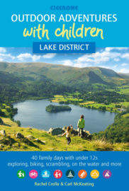 Wandelgids Outdoor Adventures with Children - Lake District | Cicerone | ISBN 9781852849566
(ISBN: 9781852849566, 2019, 224 pagina's)
De Cicerone wandelgids en/of fietsgids heeft een handzaam formaat en de informatie in de gids is steeds bijzonder compleet. De tochten zijn geordend per streek, met diverse uitstapjes in…€ 16,99


boekwinkels zitten er bij mij in de buurt ?")